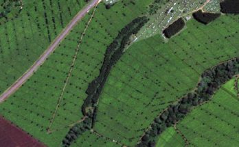
PMFBY: Using satellite imagery for assessing farmers crops
The government is also using satellite imagery to assess the crop area, crop condition and crop yield, at district level, under various programmes
Read MoreAgriculture News, Farming News, Research, Horticulture
The government is also using satellite imagery to assess the crop area, crop condition and crop yield, at district level, under various programmes
Read MoreAgriculture minister urged the states to create awareness among the farmers on water conservation practices through drip and sprinkler irrigation and water harvesting
Read MoreFuture Generali India Insurance Company has been authorised by Government of Karnataka to implement Pradhan Mantri Fasal Bima Yojana Scheme in the state
Read MoreSmartFarm, CropIn’s digital farm management solution, captures the precise location and size of the farm and the details of the farmer at the time of conducting the CCE. This ensures the field data is accurate, enabling complete visibility and transparency in the CCE process
Read MoreSpace technology helps getting fast and accurate information about the crop situation in the country. It provides digital data, which is amenable to various analyses
Read More